


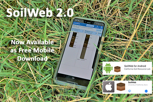
Aug 5, 2019SoilWeb 2.0 app update released by NRCS, UC Davis
USDA’s Natural Resources Conservation Service (NRCS) and the University of California at Davis Soil Resource Laboratory have released the iOS and Android SoilWebapp, version 2.0. The app now has a cleaner and more modern interface with GPS-location-based links to access detailed digital soil survey data (SSURGO) published by the NRCS for most of the United States. The newly updated SoilWeb smartphone application is available as a free download on Google Play  and Apple App Store .
“SoilWeb reached a new milestone this year when it was integrated with Google Maps and designed to scale across any device, desktop, tablet or smart phone,” said NRCS Chief Matthew Lohr. “SoilWeb app is a portable interface to authoritative digital soil survey data from NRCS, giving users access to practical detailed scientific soil information on the go.”
The SoilWeb app provides users with information relating to soil types that are associated with their location. The images are then linked to information about the different types of soil profiles, soil taxonomy, land classification, hydraulic and erosion ratings and soil suitability ratings. Identifying soil types is important to understanding land for agricultural production purposes and determining flooding frequencies and suitable locations for roads or septic tanks.
SoilWeb provides growers, gardeners, landscapers and realtors with information relating to soil types and how to optimally use the soil. Although soil survey information can be used for general farm, local and wider area planning, a professional onsite evaluation may be needed to supplement this information in some cases.
“SoilWeb is a great way to understand the landscape you live in,” said Anthony O’Geen, UC Davis Professor and Cooperative Extension Specialist in the Department of Land, Air and Water Resources. “Producing food, constructing structures and maintaining landscapes all depend on this little understood, but critical outermost layer of the earth’s crust, the soil.”
The app gives access to valuable scientific data through modern technology. All the soil information in SoilWebwas collected from the National Cooperative Soil Survey, organized by the NRCS, and accesses soil survey information the agency has been collecting since the 1890s. The resulting database, the largest such in the world, makes it possible for soil scientists to generate specialized maps using computer-aided techniques.
O’Geen developed SoilWeb with NRCS Soil Scientist Dylan Beaudette, in 2010 when Beaudette was a Ph.D. student at UC Davis. The app was a popular download, but by 2017 was no longer in compliance with requirements set by Apple and Google. Frequent users of SoilWeb had to rely on the web-based version from 2017 to June 2019. Any users with the older version on their phone can do a simple update to access the newest version. The app is a product of a 14-year partnership between NRCS and UC Davis College of Land, Air and Water Resources.


Current Issue

Veg Connections: Heat-tolerant broccolini can integrate with clover living mulch
Farm market survey shows labor, input costs driving farm market pricing
Bedner’s: Popular South Florida agritourism, farm market destination
Organic Grower: Good Humus Produce’s community mindset
Workforce solutions: best practices
Ag Labor Review: Bridging the political divide
Farm Market & Agritourism: Effective methods for collecting customer data
see all current issue »